Have you ever wondered how Google Maps knows where you are and where you need to go next? Basically, most people currently rely on geographic information systems in order to find their way from place to place. Geographic information systems are a combination of software, hardware, user information, and of course- people who use and exchange this information.
Therefore, all online mapping tools such as Google Maps, directions, and location services constitute GIS systems. While GIS systems are the umbrella of the whole technological minefield, LIDAR is a particular technique within GIS. Combined with GIS technology, the technique offers unbeatable results as far as modern-day technology is concerned.
This is what popular LIDAR technology does.
1. Better than aerial mapping
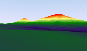
LIDAR provides several benefits over traditional mapping techniques and is several steps ahead of aerial mapping. Instead of only focusing on commercial mapping for regular users, LIDAR focuses on providing more specific mapping for areas such as urban planning, floodplain mapping, forest inventory, etc.
2. High accuracy
If your Uber stops a door or two away from where you actually are, it is because aerial mapping and other location mapping technology is a little less sophisticated than LIDAR. LIDAR is highly accurate, which is why it is used specifically for floodplain delineation, urban planning, forest inventory, and other forms of terrain mapping.
3. Higher sample density
The sample density of LIDAR is substantially more than any other form of mapping technology. Therefore it improves results and accuracy in important planning projects. The technology can be integrated with other forms of data collection to get highly accurate results.
4. Active illumination sensor
The active illumination sensor allows night vision and photography and mapping to be conducted at night or during the day. Therefore, LIDAR is not limited by daylight and is just as accurate during the night.
Regular photogrammetric techniques are limited in this regard and usually aren’t as effective during the night or in the dark.
5. Can look through thick forests
If pictures need to be taken of a terrain covered by a thick forest, LIDAR is the best technique to use. It can accurately take clear pictures of terrains with dense canopies covering them. Therefore, it is perfect in compromising weather, for messy terrains, or projects in which articulate information and accuracy are imperative.
6. It is expensive to analyze datasets
The LIDAR technique is not necessary for every project, so it is important to understand when it is and when it may not be required. Not every project requires such an extensive data set. The larger the sample, the more resources required to process and analyze the information- and most of LIDAR’s data sets are huge.
Therefore, the technique is only good for certain data collection projects but is not affordable for all.
As mentioned above, LIDAR, combined with GIS, is usually used for several mapping projects and information collected via the radio magnetic techniques of LIDAR is used in GIS.