Environmental science refers to a biology branch that focuses on the study of the natural world relationships with other organisms and the environment. Conversely, remote sensing refers to the science of gathering earth’s information through the use of satellites and aircraft. The representation of spatial data on maps is very helpful especially when it comes to environmental science. It is a tool used for planning and management. The data analytics techniques have been evolving over the years from descriptive maps to perspective. The perspective maps display data on geographical information systems which are visual information platforms.
GIS and remote sensing is a powerful tool in environmental science. It displays real-world spatial data for environmental management, mapping, and planning. There are two classifications of remote sensing in the environment that is passive and active. Passive sensors respond to external stimuli, by recording the natural energy emitted on the earth’s surface. Conversely, the active sensors collect data by using their internal stimuli. A laser beam is the most common example where data is collected by the use of projected lasers. Furthermore, it has a wide range of applications when it comes to environmental science. For example hazard assessments, natural resource management, ocean, and coastal applications.
Applications of remote sensing in environmental science
1. Drought monitoring
Throughout history, drought has been wreaking havoc to human societies. Since it is caused by a multitude of factors, it is hard to monitor without remote sensing and GIS data. The first impact is caused by a deficit of precipitation. Furthermore, the lack of precipitation and excessive use of water resources is the one that causes hydrological drought. High transpiration and evaporation causes can result in soil moisture draught especially when there is no adequate irrigation. Remote sensing monitors all these factors and stores data in GIS to be accessed by researchers.
2. Desertification monitoring
Desertification can be simply defined as encroachment of the desert. It can be long-lasting and sometimes irreversible conditions. Deserts forms slowly because they depend on many factors, for example, climate change and harsh human activities. Remote sensing monitors the man’s influence and also the climatic conditions to determine areas that are transforming into deserts. Food and meat production declines because of the poor state of the soil. Another major cause of desertification is over-cultivation and soil erosion. All those factors can be tracked by remote sensing and GIS data.
3. Land management
Remote sensing is a very critical tool when it comes to land management. Both researchers and farmers can use this data to garner physical characteristics because they are deterministic of what purpose the land will serve. The physical characteristics are mostly accessed through aerial photographs taken by satellites, aircraft, and drones. These tools produce resource maps and also help in monitoring environmental changes. Remote sensing in land management mostly involves the use of digital images whereby computers process information automatically.
4. Forest management
Effective forest management is always achieved by proper usage of GIS and remote sensing. Satellite photographs are important for researchers and forest authorities. Remote sensing maps contain a lot of details such as the different types of species available in the forest. Furthermore, it shows the areas that are affected by forest fires or other calamities such as strong winds and heavy downpour. Forest authorities and researchers always use this data to protect the forest from harmful human activities.
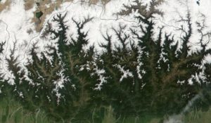
5. Mountains monitoring

Mountains are very vulnerable when compared to other regions in the world. They have undergone vast dramatic changes over the last couple of years. For example, less snow and melting glaciers which are constantly making big impacts in the water regime. Furthermore, the existence of some mountains is being threatened by landslides, glacier lakes outbursts, and rockfalls. Besides that, the mountain and forest-agriculture and all-natural ecosystems are now under pressure. Therefore, understanding and monitoring various changes is a very important task. GIS and remote sensing are the most adequate ways of monitoring and managing mountains.
6. Water management
Water is a very important part of our life. Without it, nothing can survive on the surface of the earth. Recently satellite images have shown possible traces of frozen water on the moon, Saturn and Mars. Some researchers also argue that there is flowing water on mars only that there is no enough evidence to prove it. The best way to monitor water, especially the big masses is by the use of remote sensing data. Water is like a force that controls the earth and it has to be monitored closely. Sometimes what we call the driving force of the earth can turn sour. For example, lakes, rivers and sometimes oceans burst their banks to claim the lives of innocent people. Monitoring such events by the use of remote sensing can save lots of lives and also help in conservation.
7. Soil management
Land use has caused major changes over the earth’s surface over the last couple of decades. They are likely to continue because of climate change and demographic pressure. Hence monitoring tools such as remote sensing and GIS are very important in this context. It helps to monitor and plan for carbon cycles, soil erosion, water resource management, and excess management. Furthermore, you can use GIS to access soil characteristics for over the last 3 decades
8. Landform change monitoring
In landform change monitoring things like GIS and remote sensing techniques are very important. They analyze and monitor things like crustal deformations and so on.
Accurate measurements are sent to the database for future research reference. The data is important especially when it comes to the field of agriculture. Farmers use this data to determine areas that have rich soils. Furthermore, landform monitoring data can be used in the building and construction industries. For example, when finding areas suitable for construction engineers use remote sensing data.
9. Research Purposes
Research is very common in all fields that involve remote sensing and GIS. For example, satellite images are sent to the labs and higher institutions. When this data arrives on such destinations, scientists go through it to fill missing parts and to analyze the whole phenomena
Great!