Conservation can be said to be the improvement and protection of natural resources or biodiversity from going into extinction or depreciation. The goal of conservation is to reduce spoilage and destruction of human or natural resources to benefit from its everyday provisions like food, shelter, and relaxation.
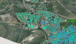
Geographic information system (GIS) is a top-class technology that has been developed for capturing, analyzing and displaying data from around the globe that would be used for future purposes. Over the years, man’s use of GIS in every of their work and portfolio has made these things easy and less stressful as it would have been when manual techniques are used.
The application of GIS in conservation is a big investment for scientists and researchers as it will reduce the hectic nature of the work. A lot of daily human activities like burning, forest degradation, and different pollution mechanisms. These issues are alarming and need immediate action which will be boosted by the application of GIS.
Through the use of aerial photographs and satellite data, information on areas of the earth that need urgent attention will be known, like hazards, earthquakes, and others. GIS also provides solutions to these problems, with this, you can see that it’s very important.
Below, I will give you a few important applications of GIS in the conservation of the environment.
1. Forest fire management
Forest fire is a major disaster that has destroyed our natural environment that has made most plant and animal species to go on extinction. Digital elevation model (DEM) is a GIS tech that helps in sensing flames to discover a fire accident that is about to occur. Also, it detects fire hazards through maps so the fire service team can locate the scene before being alerted by onlookers.
With this, fire services can work with GIS and make sure a fire outbreak is prevented before it becomes wide. GIS will make you simulate the forest fire so it will not widen and affect other parts, in other words, so it wouldn’t be severe.
2. Proper management of natural resources
GIS impact on our environment is growing daily as man has become well acquainted with its abilities. This technology helps to manage the natural resources, that is, the effects of climate, flooding, earthquake, and other land issues out there. Managing these issues and how they affect the earth wouldn’t have been possible without GIS.
GIS in correlation with remote sensing identifies these environmental conditions and takes steps to overcome it before it surfaces on the earth. For areas that are prone to these destructions, GIS observes and controls the effects by taking resistance and protective actions to reduce the effects on the earth’s crust.
If we as humans want strategies to overcome these bad environmental conditions, we should encourage the use of different GIS technologies in all countries so our tomorrow can be better.
3. Land vegetation use/cover
A GIS helps to detect the changes in vegetation land cover to know if it’s about to be destroyed by an environmental force. A lot of land degradation activities do occur unknowingly to environmentalists and the government which shouldn’t be so.
With the help of GIS, any illegal activity that is about to be taken in the environment would be known before then through satellite images and maps. These covers are important to the soil and also serve as habitat to most species, if not protected from destruction, could lead to their extinction. But with the recent development of technology and the introduction of GIS, unwanted land cover activities would be stopped.
4. Prevention of the effects of volcanic eruptions
Most volcanic eruption back in the days does come unexpectedly because there was no technology to predict its eruption at that time. This environmental disaster is dangerous to both human and plant life or the ecosystem as a whole.
As we know, these hot liquids will melt everything it comes in contact with and will make that particular area unproductive or without life for a long period. Early detection of this disaster through GIS will give environmentalists the right planting steps and time frame to prevent the destruction of their crop plants and also, take away plant species from that area to prevent death.
5. Environmental analysis
Conservation of our natural environment cannot be achieved unless supported by men who know the relevance of these resources. Due to the development of technology and industrialization, bridges, firms, companies, and airports are constructed and nobody pays attention to the resources that are being destroyed.
With the help of GIS in correlation with environmentalists and other natural resources agencies, areas that are important for planet earth will be mapped out to avoid being destroyed. Through satellite images, habitats of nearly extinct species will be located easily and these habitats will be preserved and protected against industrialization so these species will not go extinct. GIS provides information on areas that have been badly affected by industrialization and if found still manageable, conservation techniques would be applied to regain its productivity and richness.
6. Effective water management
There are a lot of problems with the use of water in the environment. Water has advantages and disadvantages to the environment. It depends on how it is being used and managed. For example, the conservation of the sea is important, because if contaminated, it will lead to the destruction of species that live in it. Water is a universal solvent and has a large percentage in the earth’s crust but when not managed in the right way, a lot of problems will emerge.
Soil erosion is caused mainly by waterlogging in an area and the process destroys vegetation and large farmlands. With the help of GIS, areas that are not good for crop farming will be known on time, and planting in that area will be prevented. But, if the area is large and good for crops, planning steps will be taken to make it suitable for planting.
GIS is will give you the right decision steps to take in citing vegetation areas and also help you protect these ocean areas from contamination from oil spills.
In conclusion, with the above-listed applications of GIS in conservation, our world would be a better place to live in. GIS would help you conserve the land areas in the best possible way, through mapping and application of other techniques to prevent future disasters.