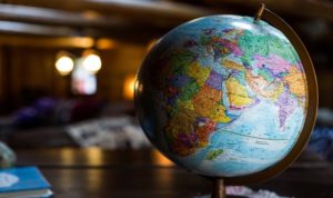
A Geographic Information System (GIS) is a computer-based technology that helps in locating, analyzing and displaying data to the best of human benefit. Through the help of its satellite images and geographical maps, it can locate and give a full description of a particular area that would have been stressful and difficult to locate.
Over the years, GIS has been in constant use by the people and has developed in its functions and abilities. It can be applied in almost any aspect of concern in human life no matter how congested it may seem. In the case of data storing and analyzing in correlation with remote sensing, it has made the world a better place.
There are a lot of private companies and organizations out there that are in search of GIS to handle their activities. The use of GIS is not only restricted to firms and industries, but people can also use it for their private work and their homes, agriculture, and others that we will emphasize later on.
Uses of GIS
1. Buffering
Buffering is a distance, zone measurement technique that is widely used around the world for measurement of the distance between buildings, roads and other proximities. Through the help of its three major areas which are; lines, points, and polygons, it can help to create a region around the earth that should be protected from human destruction like industrialization.
Buffering has a lot of applications when used with GIS as it makes work easier for workers and companies. Some land areas would be of great benefit to a particular project which can only be located with the help of geographical maps. After the location of the area, buffering is applied to help in easy work on that area and it identifies problems that may affect that area In the future. With that, the information gotten from buffering will be stored in GIS data for future reference.
2. Mapping data
This is one of the most important uses of GIS if not the most important or used. In solving major problems around the globe, data needs to be taken and presented graphically or in a map for easy view and in giving solutions. A lot of data information has been lost in the past that would have been of significant benefit to the human race, but because of careless storing, these data are lost forever.
As of now, in the modern age, data is stored with the help of GIS so that information can be gotten easily with much stress. GIS mapping also helps in wars, as you can locate the location of your enemies and know areas that they would possibly hijack and inhabit, with this, easy and right decisions can be taken against these enemies that would lead to victory. Mapping of an agricultural area that would be suitable for crop production is also applied with GIS which would give you the best answer possible. Unavoidable errors due to manual mapping methods would be avoided with ease as far GIS is concerned.
3. Spatial analysis
Spatial analysis is of great significance when it comes to GIS. A full analysis of areas can be taken with the geographic information system, unlike other manual analysis methods. GIS gives you full information about an area and if it seems difficult to comprehend, it helps to interpret for better understanding.
Spatial analysis technique, when applied with GIS, helps in better decision making and in carrying out diverse and bulky problems around the globe. Police and security agencies without the help of geographic information and data would find it hard to locate crime scenes. Even if they do locate the scene, it may be too late and their further investigations could lead to no effect. GIS gives them the edge over criminals and helps them to know the possible whereabouts of the criminals with the aid of satellite images and digital videos. The same applies to large areas that need spatial analysis like the market, sea and any other thing around the globe, although, we will emphasize more on the above in GIS application.
Types of GIS
1. Vector data
Vector data is based mainly on activities that are carried out in the earth crust and it can be divided into;
a. Polygon
b. Point
c. Line
Polygon is used to set boundaries between large areas like forest land and cities. Polygon measures distance between these areas and helps to create demarcations to achieve a particular goal. With the aid of maps, these intersections, demarcations, and measurements can be taken accurately avoiding common errors in the process. In the map, these demarcated areas or boundaries between cities can be identified by patterns, color, and numeric description.
Point data involves setting and pinpointing features or places that are important at that moment. Point data gives you the exact information with no need in measuring the distance between areas. Relevant areas can be known, located and identified in the maps by their names or easy description symbols. For example, if the oil is discovered in an area close to a particular school, it can be easily identified with its symbol on the map.
Line data involves using linear or straight or linear lines to describe and identify features in the earth’s surface. Seeing lines, it’s easy to understand that you’re identifying rivers, roads, and streets. Linear data is the easiest data of the three types of vector data, as you tend to measure length only which is very easy.
These lines can be identified from each other with the aid of thickness and colors. So when applying it, that is, through GIS, easy routes to a particular place can be seen on time without stress, then the distance to that place would be known immediately.
2. Raster data
Raster data is much more complicated I would say as it involves the taking of images on both ground and aerial level. This data with the help of satellite images helps in calculating elevations and measurements that concern the environmental stability of planet earth. For better understanding, raster data can be classified into two categories that include;
a. Pictures
b. Spectral data
c. Thematic data
Pictures are the images taken either from aerial or land view and they are very bold and clear for easy detection.
Spectral data involves grouping or classifying of these satellite and aerial images to easily get the best information or data possible. This information is divided into different spectral descriptions for easy identification and provision of a solution to problems.
Thematic data I would say is the most important and used of the three categories of raster data. Digital Elevation Model (DEM) shows the elevation data or information from the map or image and gives better clarity and understanding when wanting to solve a problem.
Before we take a look at the applications of GIS, let’s talk about the best software or tools of GIS. In using GIS, you’ve got to select and make use of the best of its tools for best functions if the project you’re about to work on is bulky and technical.
These GIS tools/software are best used when their functions are well known and applied by the user. Below I will give you a few of this software.
GIS SOFTWARE/TOOLS
1. ILWIS
Integrated Land and Water Information Management (ILWIS) is important software that aids in editing, manipulating and displaying geographical images and data. Workers who have tested their capacity in management carry it in high esteem and recommend it for other management. This software works in conjunction with remote sensing and gives enhanced information on activities that it is designed to work on. Civil engineers, hydrologists, and other geospatial users use it to excel in their place of work.
2. GRASS GIS
Geographic Resources Analysis Support System (GRASS GIS) is a top-notch software/tool that was designed to analyze the manipulating and processing of digitalized images and information. It is one of the most used software globally if not the most used among the rest.
Initially, it was an expensive software that you got to pay much before you can purchase it, but currently, it is for free. This system gives you a clear point of analysis, visualization, and vector analysis. It was designed by a team of engineers to help in processing difficult data that wouldn’t be possible to crack unless GRASS GIS is applied.
3. QGIS
QGIS which is known as Quantum GIS is an advanced GIS software used for producing and interpreting high cartographic features and digital map features.
It’s for free and it gives users the chance to create, edit and access geospatial data from an available map or images, it has a whole lot of advantages, which include; freedom of access, compatibility, dependency, good at safeguarding information and speed in producing results.
QGIS has a large fan base because of the above advantages and freedom of access, although its security and privacy could be at risk, they’ve got that covered and make sure they are no piracy, scam, and theft.
4. GVSIG
GVSIG is a powerful and world-wide known GIS that is designed to capture, analyze and solve technical issues relating to geographic data or information.
It can be applied or used in a desktop form so it won’t be complicated for those without a personal computer. With your mobile phone, it can be used in the field to capture images and get data that is important for a particular project. In its functions, it makes use of vector data which applies, points, lines, and polygons to measure distance. After which, the said information is solved and analyzed with gVSIG.
5. SAGA GIS
SAGA GIS which is known as System for Automated Geo-scientific Analysis is a GIS software that helps in solving statistical or algorithms related problems in the geospatial world. Its operating system procedures are kind of technical and confusing if not practiced.
With the aid of windows, analysis on maps, land planning, and others can be easily carried out. It tends to give out full functions of its ability but it is not as dependable as QGIS and Gvsig.
6. GeoDa
This software system is best used in solving statistical problems or in getting statistical spatial information. It is a popular GIS software that is easy to use and understand. Most companies and health organizations have embraced the use of GeoDa in taking an analysis of data.
Most underdeveloped nations are first introduced to this software system for use. It’s kind of an introduction to GIS software before moving to the use of more advanced systems.
Applications of GIS
Our modern world is changing and developing every day both are lifestyle and technology. In the best, people best believed in hard work and striving hard to survive, but, that is not true because you can work hard and also work smart.
With advanced technologies like GIS, projects and stressful works would be easy to work on and take a short time to do that unlike using manual methods or systems. GIS application is so wide and diverse because it can be used in all aspects you so desire. As far, you know the right procedures in applying it to your daily activities or project work, life becomes easy.
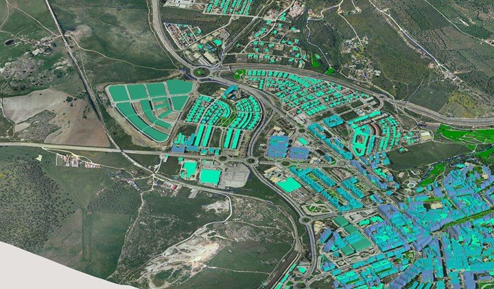
1. Architecture/building planning
This is a technical and broad application of GIS because it is very stressful and tiring. Architecture is the art of designing buildings firstly in an image before putting it to work physically. Civil engineers are the ones that pass through this demanding aspect, it requires consistency, commitment, and dedication.
A geographic information system captures, analyzes and renders solutions to that difficult task. Building a large industry or company in an area requires careful studying or reconnaissance survey to know if that area is suitable and comfortable for you. GIS is best applied in this situation with the help of satellite images and digital maps which not only gives you a clear picture of what you desire but also, interprets and gives you recommended answers to what you seek.
A CEO of a young company would want to make sure that area is ok and conducive from anything that would disrupt his peace, so would find areas that are free from;
a. Noise
b. Conducive environmental conditions
c. Easy to view/locate
d. Free from overcrowding
The same applies to engineers and managing directors who want to establish an industry, use geospatial analytical systems to check for some land problems and how to solve them easily.
2. Forestry

Forestry is the science of planting and growing trees in forests. There are a lot of forest activities that need the help or assistance of GIS. In the forest, there are mature trees that are old and due for felling but may rot and die if not located and harvested on time. Forest inventory has to be carried out for the above process and would not be faster and accurate unless through satellite images and geographic maps. This equipment is dependable and efficient in their work.
With GIS, illegal felling of trees will be known and stopped even before the theft is done. Also, fire hazards can be identified and stopped on time before it spreads to other parts of the forest. GIS has software and sensors which help to perceive and locate the direction of flames or fire and carry out immediate work in the forest.
In the modern days, due to the nature and scope of forestry which is now being taught in schools, GIS techniques can be applied for better understanding and to solve issues relating to forestry.
Finally, as an addition, GIS would help to maintain a good management process in the forest by the forest officer/guard. Through maps and spatial images, trees that are affected by disease would be identified, trees will be planted at the right quantity and right time to avoid over-crowding that may lead to the death of the trees.
3. Agriculture
This is kind of related to forestry but more precise and risky to diseases and damages to crops. Climate plays a significant part in afforestation, because, if the climate condition is not favorable, the plants planted will not grow and may stop halfway in the process. GIS gives farm researchers and scientists the edge over others as they tend to know whether the land will be suitable for the growth of the crop plant at that period. At that moment, an awareness platform will be made known to people to avoid loss of crops in the future.
With GIS, pollution can be controlled by restricting industries from plowing with the soil by introducing oil pipes which when burst, can kill plant life for now till the future. Different farm or agricultural problems will be easy to solve as far as GIS application is done. With it, you can manage the activity that goes on in your farm by taking the right decisions before the problem goes viral.
Through the use of models in GIS, new things like planting methods/technique/duration of using a breeding process can be discovered, and used in the farm.
4. Banking
Banking is an interesting platform for the use of GIS. First of all, GIS helps to improve the use of mobile banking in the banking sector. In the modern age, customers tend to use mobile banking to do all financial transactions from the comfort of their home or place of work.
With the use of GIS, security in ATMs will improve, as anyone that robs a user of the ATM can be located with satellite images and geographical videos.
Most private banks compete with each other and a quality reconnaissance survey needs to be carried out for the location of the next branch. With GIS, areas of the large population can be located easily, not only that, an advertisement can be made to the area for people to know that a new branch is about to be planted.
A GIS creates an avenue for customers to air their views, lay down their complaints and problems they encounter daily, so the bank officials will work on solving these issues. With this, the bank itself will not be full of customers all the time that sometimes leads to the discouragement of these customers from using that particular bank anymore.
5. Crime
This is one of the most important of GIS in our modern world. For a successful crime reduction or total deletion, GIS has to be used constantly. In the case of an emergency call, GIS has created a platform in which without giving a full explanation of your location of kind of crime that is about to happen, the police will know and discover it on time, then proceed with an action.
Another scenario related to that is, police and security agencies can easily predict the next crime scenes by criminals. A careful study of the digitalized files in the GIS, past crime situations can be used to predict what may happen next.
Also, criminals will have no way to run or hide because their names and total biography have been kept safe in an information system that can’t be erased thereby leaving them naked. With geographic maps, a criminal would be located and apprehended on time.
Common crimes like, drug pushing, child trafficking, and others would diminish daily because videos and digital images are up there In the satellite that any of such crime will be known and stopped before it even begins.
So, vehicle theft, runaway thief, kidnapping will reduce because all can be known and located easily with the application of GIS.
6. Weather Forecasting
A scientist does forecast the occurrence of rainfall, earthquake or other weather conditions, but sometimes, there turns out to be false. This could be as a result of inaccurate technologies that they apply for weather forecasting.
With the introduction of GIS, all of those inaccurate predictions will stop. GIS has so many top-notch tools, software and models that it uses to predict things that happen in the earth crust, one of those things is the weather.
Geographical maps and satellite images play an important role in weather forecasting because, before anything happens in the earth, it would be sensed and noticed in the satellite region, in which scientists can identify, interpret and give us the right prediction.
So, weather occurrences like; storm, earthquake, hurricane, rainfall, and others would be sensed and reported on time so we won’t be caught unaware. Apart from predicting by the scientist, visualization by the people can be possible with the use of GIS. With this technology, the 3D atmospheric view would be in the TV sets of everyone that so desire to see it. This platform would be great as apart from sharing weather information in the news, people would still have a good view and know what is going to happen.
Severe weather occurrences can be viewed and stored and kept safe with GIS. This information or data would serve as a great historical case and used in the future to lecture students and also show us ways to prevent/avoid a second occurrence.
7. Transportation
The application of GIS in transportation is necessary to safeguard and have control of the road, air, and railways. Without an effective and good transportation system, goods and services would have been impossible in some cases. GIS with its different techniques and methods re-assures the people of safe transportation to their respective destinations.
GIS is best applied in the creation of new routes of transport either on the road or railway. As the days go by, the population increases and our transport systems become congested, which leads to the creation of new routes. With GIS, discovered routes would be surveyed and checked if it has drainage and other problems. If it has it would be solved and then, a road or railway line would be formed. Geographical or spatial maps are used to easily locate new routes to reduce the congestion in our roads.
Apart from locating routes, GIS has models that can design the roads and railway for the experts, how it will fit, the length and number of lanes. That’s what makes it a global technology to embrace because it makes work easier.
GIS makes our road and railway safe for driving as spots or areas that are normally prone to accidents would be studied, made known to drivers and give everyone technique on how to avoid that same problem or accident. With the satellite and digital images, experts would easily identify common problems in our transportation system, they would make it known to the government and top agencies so work can be done on those areas thereby, preventing a repeat of such accidents.
8. Aquatic Life
Good knowledge of aquatic life is vital for the sustainability of water and the species that exist therein. Initially, it was impossible to know the activities that go on underneath the ocean but it is different now, as technologies like GIS in correlation with remote sensing as made things easy.
In this modern age, models and sensors of GIS can sense a change in the temperature and pressure of a particular ocean area and determine if it is necessary to evacuate the species from that area to prevent their death.
With GIS, data on the changes that occur in the ocean, including biological, physical, chemical and geographical will be stored, studied and observed if it’s a positive or negative change.
A GIS can also be used in keeping close tabs or track of big mammals that exist in the ocean or sea. With the aid of GPS, these animals will be tagged and can be located anywhere in the world when needed with the use of geographical maps. Their daily movement is known and by the signal that comes as a result of the trackers. This way the species can be protected from harm by other dangerous species, if the tagged mammal Is swimming to an endangered area, the signal will show and experts will find a way to protect it, or instead take all of them to a free zone free of harm.
9. Fire management
There have been a lot of fire accidents recently that have led to the loss of life. This accident is usually caused by electricity and other in house electric equipment. Most of the time, the reason why there has been a loss of life is due to the delay in alerting firefighters or the late call of these firefighters.
A GIS model should be introduced to all homes to easily locate flames and the source it’s coming from. When the fire is too large to be reduced by an extinguisher, firefighters are called with GIS software for easy location.
With GIS software in correlation with geographical maps and images, the kind of fire incident and scene of occurrence is picked, thereby causing an immediate action.
10. Conservation
With the help of GIS, every natural resource on planet earth can be preserved and sustained adequately. In recent years, they have been illegal bush burning of forest trees and vegetation which is not supported by the government. GIS with the use of satellite images and geographical maps, those persons that do the above will be located and apprehended in no time.
Also, if there is a case of a perceived fire incident in any vegetation, GIS maps can easily locate the area and strategies will be taken to stop this fire from spreading.
GIS helps to visualize and have full control of the activities that go on in the wild and sea. Cases of oil spillage in seas have a horrific effect on the species that live therein. With the aid of GIS software, any of such disruptions will easily be noticed and actions will either be taken to rescue the animals or to cleanse the water from impurities.
GIS technology helps to preserve and protect animals in the wild from going extinct by protecting their habitats from the destruction of flood or fire. If a particular animal is observed to be going into extinct through spatial analysis, a reserved area will be created to keep these animals in safety.
GIS application in our modern world is very significant and improves our sustainability of landforms and builds productiveness in our daily work. Every data or information gotten from the GIS technique is analyzed and stored in a safe digital file for future reference.