In telecommunication, a buffer is a routine or storage medium used to compensate for a difference in the rate of flow of data, or time of occurrence of events, when transferring data from one device to another. Buffering process involves protecting the most important world features from coming in contact with each other, as a result, they would be protected from natural disasters or commercial/industrial disturbance.
Geographic information system well known top-class technology that provides spatial and statistical measurement, description and analysis to searched information. Through the aid of satellite images and geographical maps, answers to different formulas and problems would be delivered.
GIS can be applied in various areas because of its wide scope and functions. It can be divided into two categories depending on its application, these categories include;
a. Vector- that can be represented in points, lines, and polygons
b. Raster data- Involves data that is used for aerial images and everything that has to do with the aboveground.
In the case of buffering, the use of a GIS vector is applied since it’s kind of complicated and statistical in scope.
With the use of points, lines and polygon, buffering is used in the construction of rails, roads, buildings, and equipment to reduce noise. Below, I will give you a few applications of buffering in the geographic information system (GIS).
1. Euclidean buffering
This is a kind of buffer system that measures two dimensional straight lines between two points of a plane. This system that involves a more complicated measurement (plane) would lead to the introduction of geographic maps that you can’t do without.
The use of maps in this system is called geodesic buffering. At this point, buffering and GIS work together to attain a common goal. Euclidean buffering gives you a more accurate distance measurement, unlike other systems that are irregular and could lead to destruction in the future.
2. Network buffering
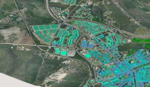
This buffering system is a more easy way of applying GIS in the measurement of road. With this system, long travel distances can be measured or calculated. An example of GIS systems that can be applied involves ArcGIS and TransCad, they function in the best possible way.
Applying to buffer in GIS reduces the risk of accidents when the roads have been newly constructed. There’ve been a lot of accidents on bridges and roads all because of bad measurements of the distance between lanes on roads which causes a crack, confusion and crashing of vehicles. Also, with the aid of geographical maps and images, areas of concern can be easily located and worked on before further destruction happens.
3. Hybrid buffering
One good hybrid buffer is GRASS, a geographical system that is used for detecting and analyzing comprehensive information. In using hybrid buffering, it means the data is broad and needs large programs for full functionality.
Also, the raster format of GIS is applied because it operates on information that is aerial or aboveground. Being aerial means that it costs a lot for its functionality and as such, used by a few except for an emergency.
4. Raster buffering
Raster buffering involves the use of aerial maps and images to estimate and make measurements of distance. The use of raster in GIS requires less power or effort because they are spatially aligned and make equal assumptions of layers during the buffering process.
Using polygon in raster buffering is the most as you tend to work on closely placed lines and between objects.
5. Water protection
With the creation of buffer zones, water can be protected from pollutants and other mechanisms that are of great danger to water. With the help of GIS, areas that are prone to water pollution will be discovered on time and steps would be taken to protect the water.
Also, in the creation of buffer zones, a small stream will be sidelined away from the harm of possible water problems. It has also been observed that through buffering in correlation with GIS, already polluted waters can be cleaned and made safe from possible future pollutions. This buffering application will also aid in vegetation protection as these vegetation need water to survive.
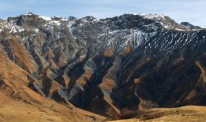
6. Mapping of a forest area
This is a very large measurement that will involve the use of lines, points, and polygons. Most times a forest land will be created and after a few years when the trees have begun growing, you will find out that the planting arrangement is irregular which could lead to destruction in the end.
Applying the act of buffering in conjunction with GIS, gives an accurate distance between plots of trees. With the aid of GIS maps, areas that are not good for measurements would be known and avoided for that moment. Buffering techniques are important so that the information gotten from its measurement would be incorporated in satellite data files for easy access later on in the future.
7. Transportation
This may seem kind of different and debatable for others, but, it is a great application of buffering in GIS. Most times, traveling to a new area is kind of difficult because you’re new to the area and could run out of road in the process is steps are not taken.
With good buffering of land areas during road construction, data on how the roads are arranged and shared should be stored in GIS for easy access by anyone during traveling. And this information stored in GIS should be the same as what we have on the ground because it could cause problems later on. Engineers often get into trouble when constructing several lanes like 6-7 in a single road, these constructions do have consequences unless applied with the geographic information system.
In conclusion, the effect of buffering in conjunction with GIS has proven to make every construction in the modern world accurate and precise. Important information is also demanded later in the future from the government on the construction of rails and roads to know if it will affect humans, vegetation and buildings. These data can only be gotten if stored in a buffer or GIS. As I’ve said before, GIS makes work easy, no matter how critical and complicated it is.