GPS or the Global Positioning System is a satellite-based radio navigation system, the United States Government controls that and the United States Air Force operates it. This system is useful during a disaster as GPS works at any place and in any weather and at any time. There are several kinds of disasters that include storms, flooding, fires, dangerous material spills, etc. GPS simplifies functions to provide the location of the receiver; the level of exactitude of GPS makes it useful enough in disaster management. The most significant utility of GPS can be seen during its response and recovery phase. GPS also can be utilized during the preparedness and mitigation phases. The considerable application of GPS in emergency disaster management is to track emergency supplies and vehicles. There are also other applications of GPS that include monitoring the height of waves, measuring the deformation of ground, examining volcanic activity, etc.
Benefits of GPS in managing disasters
When it’s about the applications of GPS for disaster management, it is also necessary to get knowledge about the benefits of GPS application in managing disasters.
- GPS applications help to deliver disaster relief to ever disaster-affected areas in a more accurate manner by saving thousands of lives and restoring critical infrastructure.
- It can provide information on a position to map the disaster affected regions where there is no mapping information available.
- Such applications of GPS can increase the capability of flood prognosis and monitoring of seismic precursors.
- GPS applications provide positional information on individuals with cell phones and in vehicles in emergencies.
Applications of GPS in disaster management
After knowing the benefits of GPS applications in managing disasters, now we will thoroughly discuss the GPS applications in disaster management.
1. GPS applications in Earthquakes
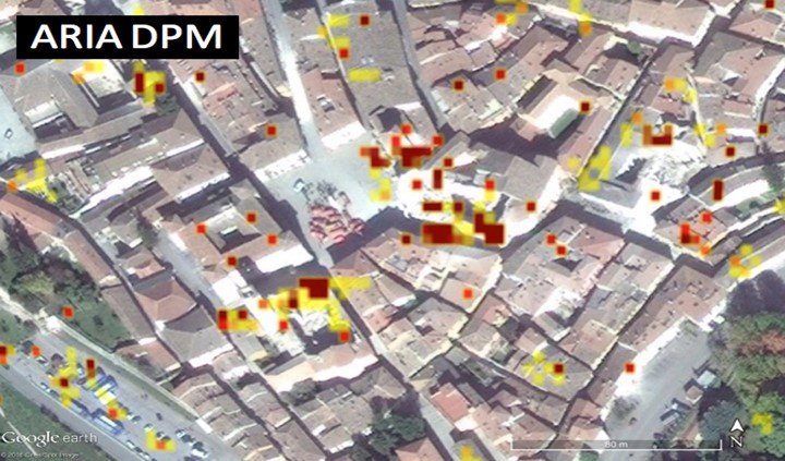
It is nearly impossible to develop an area without a high seismic risk. So, an earthquake can happen at any time at any place, and disaster can happen. Widespread use of remote sensing, mainly satellite imaging usage is difficult for the planning procedure for earthquake preparedness. This technology helps to identify the hazards of structural and non-structural earthquakes. LandSat imagery is an appropriate tool for this purpose. After an earthquake, by using remote sensing technology, it would be easy to improve the timelines and to provide quality of aid.
2. GPS application for volcanic eruptions
On-spot Seismic monitoring of volcanoes is considered as the most effective way of monitoring volcanic activity. Still, it can’t be safe or practical to be on-site always. Remote sensing is essential to monitor this process. Remote sensing technology allows disaster managers to examine volcanic activities constantly without being physically present on the site, particularly on dangerous times.
3. GPS application in Hurricanes

Hurricane prediction over the last century has drastically improved. It has been enhanced with experts being capable of estimating the number of storms for a year and the possible level and intensity of destruction. Presently, this process has been easier with the use of GPS or remote sensing technology. Trackers are capable of going to the core of the system to search for information even during the disaster. This technology is useful at any stage of Hurricane to mitigate the disastrous effects of the storm. Remote sensing technology allows planners to fathom data about the watershed features to comprehend drainage and density. This information helps to deal with the volume of water flow that could cause rain as a result of the Hurricane. High-resolution technology that is a feature of remote sensing also is useful to provide spatial information of Hurricane. As the geographic scales can be manipulated in remote sensing, users can zoom in on particular areas for study. By using remote sensing technology, coastal flooding and storm surges also can be mapped.
4. GPS application for landslides
Landslides usually happen with other disasters such as earthquakes, flooding, and hurricanes. But landslides also can occur individually. One main portion of land shift out of place, ingress to and general visibility of the affected area are common gets restricted. Images by remote sensing technology within these situations are useful in assisting planners. It provides a picture of the incident and aids in the decision-making procedure regarding the future of the slide affected area. Where measurement of areas is limited for mudflow and debris from a landslide, remote sensing technology can implant in dense areas to providing critical data. As new technologies come out, it is important to engage as many of these technological developments to mitigate the disastrous effects.
5. GPS application in Flood
Flooding is considered as one of the most frequently occurring disasters. With flooding, several risks of damage and breakdown come on normal living. Flooding affects transportation, communication, and the entire infrastructure. During flooding, it may be difficult for disaster managers to get access to remote areas. Remote sensing technology greatly helps users to monitor the flooding affected areas, without endangering the safety of the user. It gets difficult for planners to identify every flood-affected area. The usage of remote sensing technology can make the community capable of the disaster. By using remote sensing technology users get an allowance to stay away from danger zones, and at the same time, it helps to gather information to simplify timely response and relief efforts. Floodplain mapping is also a useful way to get flood indications in an area, and remote sensing technology can aid the procedure to identify flood plains.
Conclusion
Overall, it is clear that the critical component of any successful disaster rescue operation is time. By knowing the particular location of streets, buildings, landmarks, and disaster relief sites, we can save thousands of lives. This information is crucial for emergency service resources to save lives and to protect public properties. The GPS or Global Positioning System offers to facilitate technology to fulfil these requirements for disaster management. Across the globe, GPS has played a significant role in relief efforts in disasters like Hurricanes named Rita and Katrina in 2005, Tsunami in 2004 etc. Rescue teams used GPS and remote sensing technology to form maps of disaster-affected areas to perform aid operations and rescue.