Like every other major sector, archaeology is taking advantage of the progress in technology to improve and evolve. Remote sensing is now possible through the use of different gadgets and machines to offer non-destructive methods of examining history.
Applications of Remote Sensing in Archaeology
By definition, remote sensing involves collecting data about the earth without digging, or other destructive contact methods. It is very wide and encompasses different applications of modern technology. Here are some of them.
1. Unmanned Aerial Vehicles (UAVs)
UAVs, or more commonly known as drones, are increasingly finding use in many fields of archaeology. One of the major uses includes aerial and elevated photography, especially of previously inaccessible or hard-to-reach areas.
UAVs have come to replace aircraft because they are cheaper and more accessible to the average archaeologist. Fitted with a variety of instruments such as cameras and thermal imaging, they can provide detailed maps of ground features, vegetation, living organisms, and much more.
2. Light Detection and Ranging (LiDAR)/Airborne Laser Scanning (ALS)
LiDAR technology involves beaming high-frequency laser light beams at a surface and collecting those that bounce back. By measuring the intensity of the light that bounces back and the time it takes, LiDAR devices can recreate highly accurate 3D maps of the surface.
In archaeology, such devices can be mounted on aircraft on even on satellites. Such powerful beams can also penetrate water, which helps to map the properties of water over a large area.
3. Magnetic Susceptibility
Magnetic susceptibility refers to how easily a material can be magnetized. This is a property that is usually applied in archaeology to measure the mineral components found in soil over a region.
Since soil composition varies by region, its history, and manmade activity, such information can be used to draw accurate and insightful conclusions about a region.
4. Electrical Resistivity
Electrical resistivity is another physical attribute of a material that determines how much resistance it offers to electric current as it goes through it. In archaeology, this means passing current from one point in the ground and recording it at different points using instruments carried by hand or mounted on vehicles.
Data collected over a large area is downloaded into a computer where a program analyzes it and generates a map of the results. Areas with different electrical resistance show up clearly, helping to draw out patterns.
5. Electromagnetic Conductivity
Electromagnetic conductivity is the direct opposite of resistivity, where the property of interest is how much current a certain material with let through. A weak current is supplied to the ground, where metallic objects in it react more strongly. They also produce some induced magnetism, both of which are measured.
This technology has the advantage that the sensors don’t have to be in contact with the ground, and is thus faster though less accurate.
6. Ground-Penetrating Radar (GPR)
Radar technology involves powerful beams of short-wavelength radio waves. Where the ground is soft, these waves are capable of reaching depths of up to 100ft (30m) in gravel and sand, or 3ft (1m) in wet clay.
Physical and chemical changes in the ground affect the intensity of waves reflected, which are picked up by a sensitive antenna. This information can then be used by computer programs to search for underground structures and other features.
7. Large Array Geographic
Large Array Geographics is a part of a very important archeological tool called Geographical Information Systems, or GIS. It involves collecting data from a wide area using many or mobile sensors (an array). That way, you collect data not only from an area of interest but also find out how it relates to the surroundings.
This technology was used most significantly in the area around Stonehenge. It uses different types of technology, from electrical resistivity to conductivity, or even GPR.
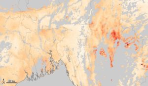
8. Satellite Imaging

Satellite imaging has long been used to provide optical and thermal maps of the earth’s surface. Recently, there has also been the involvement of laser imaging to provide more detailed, more accurate maps.
Because satellites produce large scale images, it makes it easy to pick out patterns that span huge areas. These include entire countries, continents, and the world. They are also useful for features like mountains, rivers, forests, cities, and more.
One problem with satellite imaging is that for small areas, they lack the requisite clarity to show enough detail. This is owing to the limitations in the resolution of the equipment used. Some of the best satellites are accurate to about 0.41m on the ground in black and white mode.
9. High Temporal Revisit Satellites
Temporal resolution refers to how often a satellite revisits the same area for up-to-date imaging. It is important because phenomena tend to change with time, and being able to compare two images of the same spot can help archaeologists pick up a lot of information. For example, a picture of a city during the day, and another of the same city at night, can prove valuable.
High temporal satellites tend to have low spatial resolutions, as a trade-off for high temporal resolution. Examples include the Sentinel satellites. A unique advantage to these is that their imagery is publicly available.
This is one of the oldest and best-known remote sensing methods, in the sense that it is not destructive. It involves triggering minor shockwaves into the ground, which travel deep into the earth’s crust. Rocks and liquids of different density reflect these waves at varying angles and intensities.
Sensors called geophones are placed over a large area to collect the reflected waves. The information collected this way tends to be very accurate and covers extensive areas.
Seismic waves tend to go very deep, thousands of feet underground. This is not very useful for archeologists, but there have been recent developments in a field called shallow seismic recording. It makes use of weaker waves to penetrate to only a few hundred meters into the ground. However, the cost of carrying out a seismic survey is prohibitive, so it is not very common.
Conclusion
Modern technology has resulted in a huge improvement in archeological techniques. They are moving away from the destructive digging techniques to more advanced and non-destructive ones. These ten are some of the remote sensing applications being used. They have been at the forefront of some of the biggest discoveries of the past decade.