Remote sensing refers to the science of getting information about an object without coming into contact with the object. It is mostly done by sensing and recording emitted energy, analyzing, processing and applying that information. You can also define it as the process of collecting information about the phenomena of the earth’s surface using sensors. The medium of transmission that is mostly used is the earth’s atmosphere. Different material gives different levels of radiant energy during remote sensing. This is because of factors such as surface roughness, intensity, angle of incidence and wavelength of radiant energy.
Tools that are commonly used for remote sensing in forestry are the airplanes and satellites. Furthermore, sensors that you will find in this field include radar, laser altimeter, radiometer, and spectrometer. The use of aircraft and satellites to collect photos of the earth’s surface and its phenomena is what we are calling remote sensing. It is also used in forestry to predict weather and to study forest ecosystems. Furthermore, several other ecological applications use data from remote sensing.
Applications of remote sensing in forestry
1. Predicting species distribution
It’s very hard to predict the distribution of species in the forest without remote sensing. Satellite images provide photographs that cover a wide area hence helping researchers to trace different species. Furthermore, with GIS integration scientists can get more accurate results. Predicting species distribution is very important especially when it comes to research and protection of the endangered ones. For example, an endangered species can be located using GIS and remote sensing and the get put under protection.
2. Detecting human and natural effects
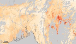
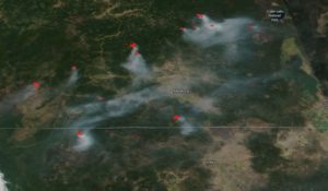
Human and natural effects may have a huge impact on the forests. A good example of the human effect on forestry is deforestation and forest fires. Luckily, with remote sensing, it is very easy to locate areas that are affected. That leads to taking necessary action faster. If the forest is burning, special satellite sensors collect data and send it to the command centers. The data received is always accurate and fast than using the manual way. Some human effects are positive, for example, planting trees and clearing the forests. Remote sensing techniques are used to help with all those programs. For instance, it provides data such as how much cover is left before completion and areas that need attendance.
3. Research
Conservation biologists and ecologists rely on data to carry on with successful research. This data is obtained from remote sensing using sensors from satellites and airplanes. Forestry research is very important because it helps come up with good products. Furthermore, this data helps the researchers to come up with ways that can improve the environment even further.
4. Land cover classification
Satellites provide photographs that help to determine the type or variety of land cover in a given area. Studying land cover is important for many ecological applications. It describes the physical and geographical characteristics of the environment surface ranging from tropical forests to bare rocks. Depending on the techniques available land cover classifications can be used to identify specific habitats. Furthermore, land cover classification helps to predict the distribution of species across broad areas.
5. Assessment of forest productivity
Satellite sensors can accurately detect forest productivity all over the world. These techniques are accurate and cost-effective in comparison to traditional survey methods. Agronomic ecosystems are increasing productivity because of the use of accurate satellite data for development. There is no other reliable way that can be used to predict forest productivity rather than the combination of GIS and remote sensing.
6. Bioprospecting
Bioprospecting is one of the globally followed approaches for management conservation and planning. Also, it helps to prioritize the areas of mapping and bio-prospecting target economically useful species. Vegetation types of maps produce information and help to identify areas of high economic value. Furthermore, when satellite images have high resolutions, they tend to give more detailed information.
7. Assessment of stand structure
Forest characteristics such as tree density, basal area, leaf area index and biomass are accessed using remote sensing techniques. An example of one of the most used tools is the thematic mapper simulator which is an airborne sensor. Furthermore, the airborne lidar transmits an average of 200, 000 lasers per second to produce a detailed forest structure. It then measures the distance from the point where the lasers split to come up with accurate information.
8. Integrated eco-system measurements
Remote sensing is a very important tool when it comes to forestry. It is used to produce estimates that are useful in improving the eco-system. Consistent photographic systems that are based on meteorological approaches have been developed.
9. Spatial patterns and Landscape metrics
Landscape metrics, connectivity, interspersion, and juxtapositions are mostly used as patterns of biodiversity. Using advanced multi-scale spatial information has become a time-effective process. Furthermore, parameters such as patch size porosity fragmentation, mostly delineate the disturbance regimes.
10. Monitoring changing Bio-diversity
Biodiversity is constantly changing hence monitoring is very important. Furthermore, data from remote sensing can be used to predict how the environment will look like when some species are removed. Typically, predicting the change of bi-diversity without using remote sensing data would be very difficult. However, now researchers can fill in the gaps by just playing with the remote sensing information to garner accurate results. For example, if you want to predict how the environment of a certain place would look like without trees then you just need to erase the trees’ data and work with the rest. The results provided are always accurate or something close hence making it a reliable source.
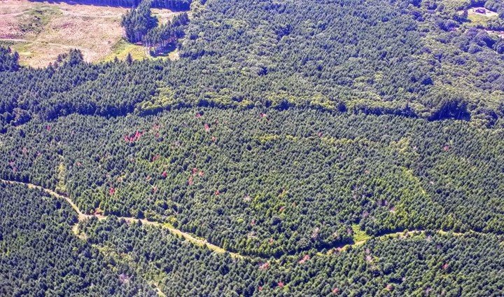
11. Assessment of forest damage

Assessment of forest damage couldn’t be easier without remote sensing techniques. Many characteristics and changes in the trees can be detected using remote sensors. Furthermore, some advanced systems such as drones and satellite can be able to classify the type of tree and degree of stress. Satellites can take high-resolution photographs to show areas that are affected by forest fire and deforestation. Responsible units use this type of data to take the necessary action.