Remote sensing is an important aspect when it comes to getting concrete information on conservation management and biodiversity. As it helps, in taking measurements on giving us a broad review of the things happening around us.
Remote sensing is a world accepted method of taking and analyzing data about the earth in which decisions are made concerning the ongoing and future state of our beloved planet. This data are analyzed through sensors (remote sensors) that records transmitted and emitted energy.
Biodiversity talks about the number and variety of species of plant and animal life within a region. Without biodiversity, there is no life, it determines our breath, the food we eat and our day to day living. In recent years, researchers have been looking for ways to sustain biodiversity on planet earth because of its services.
Why should we sustain biodiversity?
1. Biodiversity improves the earth’s resistance to various disasters
2. Biodiversity boosts productivity among species in planet earth
3. Biodiversity brings stability between plants and animals and therefore the continuity of life
4. Without the sustainment of biodiversity, there will be no life to live among ourselves, plants and animals
Application of remote sensing in biodiversity will be a great step indeed so we can know the status of our climate, temperate regions, plants, and others. Remote sensing will grant us easy ways to know the issues of biodiversity and how we can solve them through images that would be taken from satellites and advanced cameras or sensors.
Because of its wide scope and properties, it is almost impossible to take measurements and apply methods on how to sustain biodiversity, but because of the improvement in technology, we can now apply various techniques on biodiversity.
Below I will give you few application steps of remote sensing on biodiversity conservation.
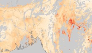
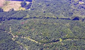
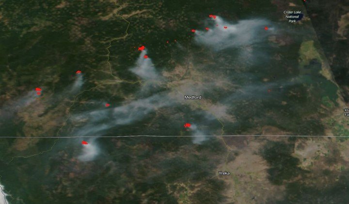
1. Fire detection and supervision
As we know, biodiversity covers a large portion of the earth’s surface and it will be very difficult to locate vegetation fires unless through remote sensing. Remote sensing gives you an accurate detection and location of a vegetation fire that would be impossible for other methods of detection.
The land and vegetation area has to be protected for healthy stability in the ecosystem, so any case of fire incidents around the globe should be detected and controlled instantly. While those tropic vegetation areas that are always prone to fire incident be supervised constantly.
In December 1999 to be precise, NASA unveiled a high-class instrument called MODIS (Moderate-resolution imaging spectroradiometer) which measures and detects smokes of active fires quickly.
2. The use of landscape and changes in land cover
This particular application of remote sensing helps to predict or know in an instance the changes that occur in the land. Remote sensing provides data or information on ecological, climatic and biochemical changes that take place on the land daily.
The sustainability of the ecosystem is man’s concern and land which covers a large portion of biodiversity should be a major priority for them. Also, remote sensors are used to detect and monitor changes that occur in the habitat. Having concrete information on the changes in landform is necessary so that unwanted changes can be dealt with immediately.
Changes in the soil, rocks, and covers could damage a lot if not discovered and solved on time. For example, illegal felling of trees could be going on in any part of the country without anyone knowing, but with remote sensors, which detects, the changes in landform, actions will be taken.
3. Determination of species habitat/distribution
There are a lot of species out there that are without homes or coverings mainly because their habitats have been destroyed by deforestation or bush burning. Through geographic information systems (GIS) and mapped remotely sensed images, animals without a dwelling place will be located, thereby creating a new shelter for them.
There is a system that makes known the habitat preference for each animal, so it won’t be difficult in establishing a new protected habitat for them. Sometimes, it may be difficult to find free land to put these different species of animals, but with Gap analysis, a high-quality habitat would be created that will suit that particular species. This habitat could be located in cities or towns but well created and set up so the animal would feel at home or comfortable and free from poaching.
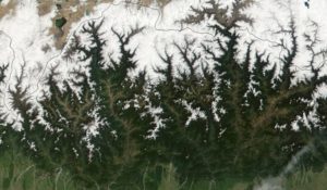
4. Forest Supervision
Forest is a very wide aspect when it comes to using remote sensors to work on it. Although, it could be large and tiring but sure an easy means to detect and estimate parameters that would be more difficult if done manually or with other methods.
Remote sensing techniques are applied to get information like, tree height, bole height, density, volume, and other important measurements. Also, remote sensing of the forest would help to prevent cases of fire hazards, insect and disease infestation.
These changes can be discovered by high-resolution aerial satellites that sense it immediately. Also, high-resolution photographs with sensitive images will help to discover if a tree is under an insect attack and then drastic actions would be taken.
5. Rainfall detection
With remote sensing, it is very easy to estimate rainfall correctly by using the microwave technique. Several times, there have been wrong estimates of rainfall by scientists because they use indirect techniques that are not accurate in their readings.
With the emergence of remote sensing, rainfall is supervised and known when to fall. Aquatic life is of great importance, so any area of land or area that has limited rainfall will be set up in such a way that it won’t lack water until its season of rainfall comes. Before that time, the drainage system will be constructed to help the aquatic life from dying because of a lack of water.
6. Sea temperature/ Ice breakage
Several microwave sensors have proven in recent years to sense salinity and sea issues like ice destruction and others. Special sensor microwave/imager (SSM/I) is an example of such a remote sensor that gives images to locate the breakage of ice in the sea that can cause a lot of destruction to ships.
With this, sea navigators can detect ice easily and quickly so that ships will divert or move away from that course to prevent the collapse of ships. Also, there are times that the sea would not be favorable to sail on maybe because of the temperature and pressure at the moment when observed and known with remote sensors, it will be advised not to sail.
A lot of sensors show you the sea currents and when it is very high, all ships will be stopped from sailing to avoid accidents on the way which could lead to loss of lives. With this, you could see the importance of remote sensors and why there should be used concurrently.
In conclusion, remote sensing is an important aspect when it comes to sustaining biodiversity because, without it, I see no other easy and efficient method out there.
Continuous use of remote sensing will make our habitat (terrestrial and aquatic) stable.