The launch of a NASA Terra satellite back in 1999 was the perfect beginning of the earth’s atmosphere remote sensing. Since then, space platforms such as CALPPSO, ENVISAT, AURA, Aqua, and Terra have provided us with seamless measurements of the atmosphere. All these data from such space platforms helps us to monitor changes in our sky atmosphere. Thanks to remote sensing now we have global observations of gas pollutants and aerosols. You can easily get any information about carbon monoxide, ozone, nitrogen dioxide, and sulfur dioxide at high precision. Any ground-based monitoring platforms cannot be compared to satellite observations because of the offer a wide spatial coverage.
Satellite data is important because researchers use it to support air quality forecasting, track pollutant plumes, and provide evidence of air pollution events. Furthermore, satellites provide detailed information on pollution emissions estimates, evaluates model performance and also study long term pollution trends. Although, some challenges need to be addressed for satellites to be fully effective when monitoring air pollution.
Applications of remote sensing in air pollution.
1. Information to the general public
It was easier to show the general public about the air quality situation today by the use of satellite maps. Furthermore, since it saves data for a couple of decades the people can be shown the comparison of the air quality in the past and now. For instance, air quality enthusiasts can use such maps for protests and supporting decisions such as vacations or housing. Remote sensing data is also used to educate the general public on how to take care of the environment. Most importantly to provide awareness on the effects of air pollution.
2. Planning of ground-based measurement sites
High spatial resolution data from the satellite is important when determining the number of ground sites that will be required. There is no need for having many ground sites since data from the satellite is always accurate. However, a few ground sites are needed for further research and air quality analysis. Remote sensing data is responsible for showing the locations in which the ground sites can be constructed.
3. Hazard warning
Large scale emission of pollutants such as forest fires can cause an alarming hazard on air. On such occasions, satellite data is used to track and quantify the number of emissions and also locate the source. However, during such instances, the satellite needs to be available in real-time. After analyzing the situation and the level of hazards, the satellite conveys data to different ground sites. The sites are responsible for taking the necessary actions
4. Impact of satellite data on policy
Policymakers mostly rely on satellite data that is related to air quality. For instance, policymakers in the Netherlands have placed air quality policies using the maps of tropospheric. These satellite maps show the distribution of air pollution at both the regional and global levels. Hence it puts the whole world into a single perspective that helps come up with ideas of conserving the atmosphere.
5. Trends in emissions

Long term satellite data records contain emission inventories records over many decades. Ground-based observations have the same capabilities to provide this type of information but satellite data has an advantage because it can cover a large area within a short time. Meaning it is available all over the world and it collects data seamlessly.
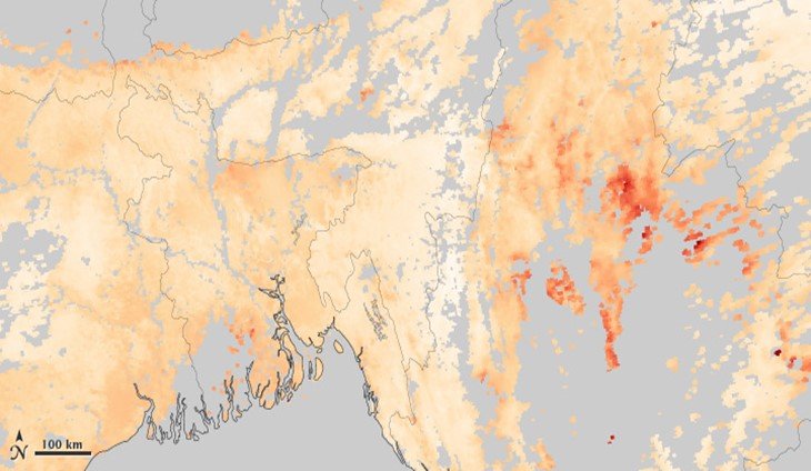
6. Monitoring long-range transport of air pollution
Long-range transport is a major cause of air pollution in areas that had less pollution before. There are no other means that are effective than satellite data when it comes to tracing such emissions. Long-range transport of air pollution refers to when air pollutants move from a certain geographic region to another. For instance from Europe to Asia and vice versa. However, such transports of air pollution can be traced using satellite data.
7. Monitoring of remote locations
Satellite data is not only available for selected measurement stations but across the whole globe. Therefore, satellite data is very essential when it comes to monitoring air pollution in remote locations. Remote locations are areas that are not inhibited by human beings such as the oceans and overseas. Furthermore, areas that are sparsely populated too can be referred to as a remote location in this context. Reason being that people in those places may not have enough resources to track the air quality.
8. Spatial distribution of emissions
Emission databases contain spatial patterns that can be compared by satellite maps of pollutants. Additionally, high-resolution maps are averaging around 10 ×10 km². Better resolution is not feasible while using ground stations to monitor the spatial distribution of emissions.
9. Air quality forecasting
Air quality forecasting refers to the use of remote sensing data to predict the composition of pollution in the air. The report always shows air quality index concentration. Cities and countries are given forecasts by local and state government organizations. Besides, private companies take part in providing such reports. The techniques used in air pollution forecasting include machine learning in combination with weather forecasting systems. Furthermore, you can also use atmospheric dispersion modeling. The forecast is usually done on an hourly or a daily basis.
10. Long term pollution trends
Remote sensing and GIS are responsible for long-term pollution trends analysis. For instance, data recorded by the satellite over the last couple of years can be accessed. It helps us to continue making environmental improvements that support quality every day. Emissions from industries, cars, and burning plastics are the major players when it comes to air pollution. Data that shows how the air quality looked like in the past can be used to create awareness across the world. Furthermore, it helps us to know if the quality is getting worse or better and by what rate.
11. Research
Research and remote sensing data go hand in hand. The atmosphere is composed of many unique gases and particles. High-resolution images from the satellite can be used for research. For instance, remote sensing data can be used to determine the rate of increase. Air pollution can be prevented, researchers are doing all the best they can to do device ways that minimize it across the globe.