The study of weather is an essential aspect of modern-day agriculture. Crop productions have an increasing demand in this modern age, and with climates changing, the firms are facing challenges to meet such demands. However, the good news is that technology is saving a lot of headaches for those who are researching crops. Firms are applying innovative means of crop production so that the increasingly global needs can be met effectively. Remote sensing and GIS applications are providing a lot of benefits. In the process, such applications allow the gathering of data to be much smoother, easier and faster. Weather information and predictions of future changes in weather can be made more efficiently. This allows crop production processes to take place in innovative ways, making crops grow more than usual, using technology.
Remote Sensing Technology
Remote sensing is usually done using various devices through several platforms and techniques. The main aim of the sensors is to obtain data that may appear from electromagnetic wave distribution in the year. There are several platforms through which such data can be collected, for example, satellites, airplanes or hand-held radiometers can easily collect these data. Any object that can detect electromagnetic radiation is usually called sensors. There can be two groups of sensors. The first is the passive sensor. Passive sensors usually do not have their own source of radiation. These sensors can only obtain reflection where the source is of natural origin. The other is the active sensor, and they have a built-in source of radiation. Radar and Lidar are two main types of active sensors. Radar is used for radio wave detection and ranging, while Lida is used for light source detection and ranging.
Technical Resolutions
Remote sensing can be of many types. It can be both analog and digital. There are different technical capabilities of various sensor systems. They have to be used the way they react better. The technical capabilities of the sensor system can be categorized into three different types of resolution.
For example, spatial resolution holds the capability to measure up the size of the resolution cell. It is usually done from the ground, the direction towards the flight, or across. The spectral resolution, however, is more concerned with the numbers, the electromagnetic spectrum location, and the bandwidth of the spectral wavelength. Using the difference in resolution within the sensors, they largely determine its potential use. The third one is the temporal resolution. This resolution mainly deals with the time lapse between two successive images within the framework of the same area. This is determined by the platform itself using the atmospheric conditions.
The Art of Remote Sensing
Many consider remote sensing to be an art. This is because several innovations can be applied to detect radio waves and collect data through various platforms. This is about collecting information through sensing, not making any object to touch the ground, or any other similar objects. It is about using the atmospheric pressure to determine the productivity and cultivability of the land. There is always a relationship between the earth’s surface and the atmosphere. The wave-lengths and radioactive brands through their movement determine the weather conditions to take effect. By obtaining the data through understanding the in-between movements of the wave pressure within the electromagnetic spectrum, allows the prediction to be made properly about future climate patterns.
Reflective and Thermal Sensing
The electromagnetic spectrum has two portions, one is reflective, and another one is thermal. The reflective portion is concerned about the changes in directions of the wavelength. Both radio waves and light waves carry some length of reflective portions, that allows the data collectors to measure the wavelength and verify the conditions of the atmospheric pressure. It basically understands the degree to which the wavelength is reflected to the air from the earth’s surface.
The thermal sensing, however, depends on the factors of ground temperature. It is about measuring the temperature levels of the ground at different times and how much kinetic energy is being released in the process. The sensors pick up such data through the variations that can be detected in the electromagnetic waves.
Micro-wave Sensing
Microwave sensing is also another important way that assists agro-meteorology. Microwave is another essential feature of the electromagnetic spectrum. In this regard, there either passive or passive radio signals that use the microwave spectrum. Both of these active and passive microwave observations can be made to understand the soil moisture and collect necessary data that is related to the overall experiment. By observing active pulses of microwave energy, the strength and polarization of the land and its soil can be recorded. The characteristics of the landscape can be determined by observing the ways the signals are returned. Both the active and passive ingredients are measured and observed through the use of Radar which is an essential feature. Radar is popularly used to determine the near-surface soil moisture.
Satellites

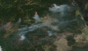
The use of both earth and weather satellite are very common for researchers to collect necessary data. The remote sensing methods of weather and climate changes are more common. Polar-orbiting provides a clear picture of information that can be acquired to make future decisions. This has been one of the most successful ways of detecting and understanding the characteristics of the earth’s surface. Such landscapes are changing fast and increasingly changing their productive abilities due to the changes in climate. The air and satellite-borne radars are very common in the usage of data through satellite information. Satellite radars provide useful information on meteorology and vegetation. Both the spectrums can be used in this regard for maximum benefits. This term is usually called agricultural meteorology and has seen a faster increase in research due to its success in recent years.
Applications of remote sensing in Agro-meteorology
1. Observation of Rainfall
The amount of rainfall can be routinely deduced through remote sensing methods. Rainfall is a very important parameter in agro-meteorology and has massive impacts on plant growth and survival. Some remote sensing techniques are very reliant on visible sensors and cloud types and each cloud type has a different intensity of rain. Researchers can deduce the bi-spectral methods from infrared observation and use it to create cloud images. The intensity of rainfall and the likelihood of rainfall are efficiently mapped by satellites and sensors.
2. Soil moisture, Irrigation Purposes, and scheduling
Remote sensing has massive applications in irrigation and groundwater resources. It is very efficient in the retrieval of Biophysical characteristics of crops. Remote sensing is used by researchers to ascertain the irrigation needs of the crops. Moisture contents and the direction of groundwater flow are very important parameters. Canopy roughness, Biomass density, and leaf area index (LAI) are some of the parameters in question and they can be correctly mapped and ascertained using spatial georeferencing, and microwave methods. Some of these crop coefficients do not depend on the planting date and the density of the soil. Data retrieved from Earth observation are very useful in research purposes and in determining important coefficient and crop water requirements. Cropped surfaces have a rate of response which is dependent on the spectral response of cropped surfaces and evapotranspiration. The microwave technology is very useful in this aspect and is done routinely by the satellite system.
3. Study of Salinity of Soil
Remote sensing is used in the mapping and identification of areas of soils that have high salinity and contamination. With remote sensing, researchers can decipher the rate of contamination in different areas of the farm. As such, they would be able to map areas of the farm suitable for planting certain types of crops. Stress, rate of leaching, and groundwater quality can all be determined using spatial data. Soil salinity is known to have huge impacts on plant characteristics, chlorophyll content, plant biomass, and red edge peak. Plants in excessively salted soils tend to experience an increase in canopy temperature and other anomalous conditions.
4. Management and detection of nutrient deficiency
There exist different remote sensing methods for determining the vegetation indices of crops and nutrient deficiency. Researchers can determine the volume of soil nutrients through spatial methods while unraveling the best methods to remedy the situation. Remote sensing studies are very efficient and quick methods in managing nitrogen deficiency in planting and can be used in proposing the yellowness index of affected plants. Hyperspectral reflectance data are used in knowing the level of availability of Nitrogen, Zinc, Iron, manganese, copper, and Phosphorus in the leaf of Plants.
5. Monitoring of Solar radiation and surface temperature
Satellites and spatial observations can provide information and data about the volume of solar radiation that reaches the plant canopy. With remote sensing, agro-meteorological researchers can measure the ambient solar energy and the volume that is absorbed in the surface. The rate of solar radiation and surface temperature have direct relationships with the development of crops and the study of soil moisture is dependent on the maximum and minimum surface temperature. They can be mapped directly via satellite observations.
The various techniques of remote sensing are definitely impacting crops harvest in a positive manner. Many firm owners are very eager to spend the extra amount in the research and development sector because previously it has brought good results. However, experts say the use of remote sensors for collecting data is still in the development phase. There is a lot of development done using technology to bring forth better usage of data and information for the productive use of irrigation.