Back then, GPS was developed to equip the military. As time passed, it became accessible to civilians as well.
In fact, many surveyors are currently taking advantage of GPS for their surveys.
Why won’t they leverage such a potent technology? As we know, they’re trusted for highly accurate measurement.
It’s surprising to note that GPS has been applied in surveying. Shouldn’t we discover its applications?
The Idea behind the Utilization of GPS in Surveys
Irrespective of weather conditions, GPS can be utilized as a perfect navigation system to send signals from satellite to focused location on or under the earth’s surface.
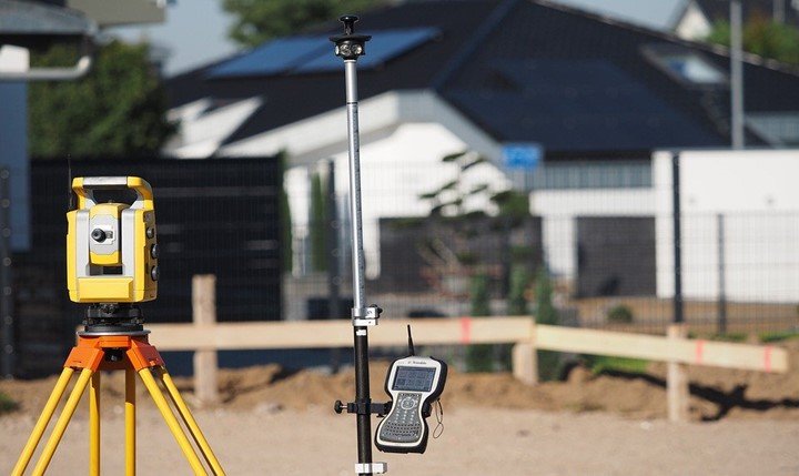
Although instruments like Electronic Distance Meter, Total Station, and Theodolite are highly used, a majority of surveyors demand a good GPS so that they can stay accurate as well as smart.
Moreover, it allows them to judge latitude and longitude without the measurement of distances and angles between two or multiple points.
From a surveyor’s view, GPS acts like an instrument. A surveyor doesn’t decide whether he wants to use GPS or not. The conditions around him decide.
Why Surveyors Need GPS to Accomplish Their Goals?
Most people wonder why surveyors need GPS to accomplish their goals.
Without knowing about the requirement, we can’t understand the applications of GPS in surveying. Thus, this is why GPS is used by surveyors.
- It increases productivity in terms of labor, time, and equipment.
- All the physical features that are used in maps and models are accurately positioned due to GPS.
- As compared to traditional techniques, a surveyor needs fewer operations to get results.
- It delivers geographic information rapidly.
- Even the centimeter-level surveying reports in real-time.
How Surveyors Take Advantage of GPS
At present, surveyors have acquired 3 methods to survey using GPS. Let’s reveal each method one by one.
1. Static GPS Baseline
Static GPS is often used to measure survey points while recording GPS observations for over 20 minutes.
Once the data is observed, it’s sent to an office for the procession. At the office, they judge the accuracy depending upon the duration they have taken during the observation.
2. Real-Time Kinematic
A surveyor sets two points to initiate this method. The first receiver is locked at a particular point, which is called the Base Station. The second receiver animates between positions, which is called the Rover Station.
After setting up both points, the Rover position is used to compute and store data, which usually takes a few seconds.
Now the question is – how does it happen?
It happens because of the radio that is linked to providing the right coordinate. Although this method is as accurate as of the baseline measurement, it only applies to 10 km of radius.
3. Continuously Operating Reference Stations
To begin with this method, a surveyor installs a quality GPS receiver in a location. We can also call that a starting point in the district.
The beauty of this method resides within the communication. Such a system can deliver data via the internet within 24 hours.
Anyway, we can view the CORS method as a more advanced way of measurement.
Basically, it’s an automated way to receive genuine data.
The Real Applications of GPS in Surveying
Till now, we have discovered how GPS is used by surveyors. From now on, we’re about to understand the real applications of GPS in surveying.
Our study is incomplete without getting the real application of GPS in surveying.
To understand the real application of GPS in surveying, we must acknowledge where it is used the most. As we have said earlier, the conditions decide the utilization of GPS in surveys.
4. Mining
Mining is one of the richest industries across the globe. In 2018, it has been revealed that the world’s top 50 mining companies together worth $896 billion.
Why GPS can’t be utilized in such a rich industry? There would be no issue with the budget. In fact, many countries have built a CORS network because engineers and the local government collect mine data with the help of GPS technology.
5. Waterways
GPS is widely used in waterways. The reason is quite simple. In such places, there are only a few land-based references points. As a matter of fact, it becomes challenging for surveyors to get accurate data with traditional instruments.
In such a case, they have to use GPS, which combines with sonar depth soundings to understand the depth of underwater and its hazards.
They measure around these areas to alert marines. Apart from waterways, surveyors also use GPS to take care of offshore oil rigs and bridge builders.
6. Surveying in a Too Cold Place
Deep in the land of Penguins, it’s not an easy task to survey.
Most people think why there’s a need to survey in such a place. We must say – it depends on the type of work and the surveyor.
Let the traditional equipment rot aside, not even modern GPS are good enough to get data from these icy regions. In 1841, a U.S. expedition covered the region of great Antarctica to prove the fact that it’s a continent.
After generations, a surveyor named Corey Biddle tried to map the survey with the GPS. His experience is hard to believe. He said, “GPS antenna cables can easily snap in the harsh cold place like this.”
The result was a victory. He was able to get data with GPS. But still, he had to address some issues to claim the throne.
Is GPS A Right Choice for Surveying?
GPS can be right as well as wrong for surveying. It’s not a good tool for beginners. From our perspective, beginners should first get familiar with traditional tools. Once they will be able to use them properly, they will be able to use GPS in an easy manner as well.
When it comes to experts, they know the proper implementation of GPS. They know how many types of GPS instruments are there and what they can leverage the most.
There’s just one major disadvantage of GPS, it’s a bit expensive for surveyors. Only a GPS receiver ranges from $4,000 to $10,000.