Differences between GIS software and hardware
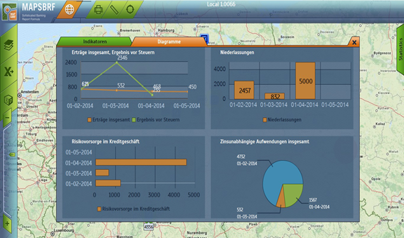
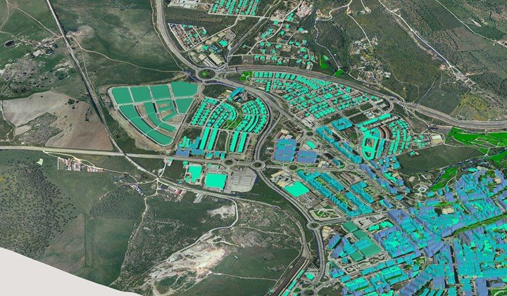
Geographic Information System or GIS for short is a computer system that is used for the purpose of being able to interpret and analyze geographical data. This is done by…
Computer Cartography is the process of converting and representing the variations in topographic data symbolically in two dimensions. It also involves mathematical modeling. On the contrary, GIS is a systematic…
In spite of the fact that there are a few similitudes among CAD and GIS there are numerous distinctions. The most principal distinction is that GIS models the world as…
A Geographic Information System (GIS) is a computer-based technology that helps in locating, analyzing and displaying data to the best of human benefit. Through the help of its satellite images…
Geographic Information System is a system that has been put in place specifically to capture, store, deploy, evaluate and present geographic data. This system has proved effective in the agricultural…
Understanding how the earth functions and how mechanisms are interrelated is at times difficult. Geographic Information System plays an important role in the study of the earth and everything that…
Have you ever gotten lost while going somewhere and needed directions? Were you ever looking for the closest bakery but had no idea whether you should turn left or right?…
GPS is short for Global Positioning System, meanwhile, GIS is short for Geographical Information System. It is unsurprising to see most people confuse themselves between GIS and GPS, given that…
Remote sensing is basically a means of being able to obtain geographic information about a particular location without needing to be physically present in that location at the time of…